
 保育與休閒部
 保育。保護。享受。
保育與休閒部 


Understanding flood risk requires knowing which areas of your community are exposed to flooding today, and which areas are expected to be exposed in the coming decades. Due to changing patterns of precipitation, sea level rise, and development, historic flooding trends are no longer a useful predictor of future risk.
Nationwide, we lack consistent, locally specific data that forecasts flooding based on multiple risk sources. The Commonwealth is closing these data gaps and providing data tools to support flood resilience planning efforts in Virginia.
DCR provides two non-regulatory flood hazard datasets that can be used together with regulatory data to support more informed flood resilience planning: a coastal Virginia flood hazard dataset (developed for the Coastal Resilience Master Plan) and a statewide Fathom flood hazard dataset (procured for the Virginia Flood Protection Master Plan). The table below explores and compares these two resources. In addition, DCR provides flood impact data for coastal Virginia to explore how assets may be affected by flood conditions. Users can access and explore this resource via the Coastal Resilience Web Explorer.
|
Coastal Virginia Flood Hazard Data |
Fathom Flood Hazard Data |
Geographic Area |
Coastal: localities within any of the eight easternmost Planning District Commissions in Virginia. |
Statewide: The entire Commonwealth of Virginia. |
Flood Hazards |
Coastal, riverine, and rainfall-driven flooding |
Coastal, riverine, and rainfall-driven flooding |
Recurrence Intervals |
Seven recurrence intervals: 1 in 2-, 5-, 10-, 25-, 50-, 100-, and 500-year. Three tidal conditions (MLW, MHW, 1.5xMTR) are also available for coastal flood data. |
Five recurrence intervals*: 1 in 10-, 25-, 50-, 100- and 500-year. |
Associated DCR Plan |
Coastal Resilience Master Plan (CRMP) |
Virginia Flood Protection Master Plan (VFPMP) |
Planning Scenarios |
Five planning scenarios: baseline (2020), plus “moderate” and “high” scenario options for the near future (2030-2060) and far future (2060-2100) time horizons. |
Five planning scenarios: baseline (2020), plus two “moderate” and “higher” scenario options for the 2060- and 2100-time horizons. |
Basis for Future Conditions |
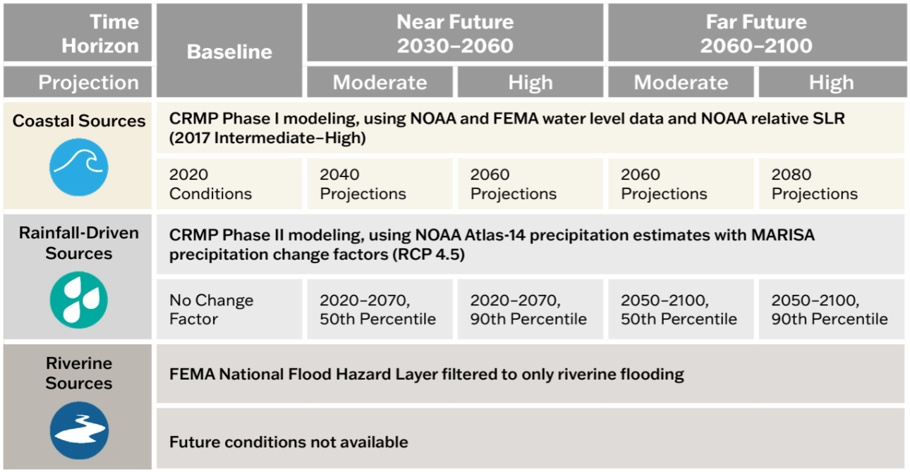
Varies by flood source and planning scenario. See reference figure for more information. |
Shared Socioeconomic Pathway 2-4.5 (SSP2-4.5). “Moderate” scenario based on median (50th percentile) values and “higher” scenario based on 83rd percentile values. |
決議 |
10-foot |
10-meter (~33-foot) |
來源 |
DCR with underlying data from the United States Army Corps of Engineers, the National Oceanic and Atmospheric Administration, and the Federal Emergency Management Agency. |
Fathom |
訪問 |
View and download data and methodology documentation via DCR’s Flood Resilience Open Data Portal. |
View the 1 in 100- and 500-year data for baseline conditions via DCR’s Flood Resilience Open Data Portal. Access to all other products is provided to VA public institutions.* |
其他資訊 |
Learn more via the overview one-pager. Learn more about Flood Hazard Data Development in Appendix A of the CRMP Phase II. Learn more about the asset data and impact assessment methodology in Appendix B of the CRMP Phase II |
Learn more via the overview one-pager. |
*Virginia government entities and state-recognized Tribal governments may sub-license all Fathom data from DCR for a 12-month renewable license term. To inquire about a sub-license agreement, including data use limitations, please contact us at flood.resilience@dcr.virginia.gov.
Additional data to visualize and understand flood hazards is available through state and federal platforms. Below is a snapshot of these data resources which can be accessed through the links provided.
There are many tools to aid organizations in crafting a flood resilience plan. Below is an abbreviated list of useful planning tools. Additional tools can be found on the information gateways linked below.
The following tools were developed with Virginia-specific needs in mind. While some are focused on exploring flood resilience specifically, others support resilience planning more broadly.
Federal agencies have developed tools to assist organizations to plan and implement successful flood resilience strategies. The following resources may help you to craft your resilience plan.
These portals and databases contain a variety of resources – such as data, planning tools and funding information – that may be useful to your organization as you develop your resilience plan:
Organizations developing flood resilience plans should consider approaches which align both with DCR’s flood resilience plan guidance, as well as with federal resources and funding opportunities. Resources to help you understand how to align your approach to resilience planning with available funding resources include:
DCR administers the Community Flood Preparedness Fund (CFPF) and the Resilient Virginia Revolving Fund (RVRF). For more information on these funds visit the DCR Floodplain Management, Flood Resilience Funding website.
Beyond the DCR administered resilience funds, the Coastal Resilience Web Explorer Funding Opportunities tab provides an inventory of funding sources that may be available to finance the development and/or implementation of your plan. While it is catered to the coastal region, non-coastal activities may be eligible for some listed opportunities.
The DCR Flood Resilience Funding Geographic Focal Area Viewer identifies geographic areas that are designated as either required or preferred for resilience funding, including Low-Income Geographic Areas for the DCR Community Flood Preparedness Fund.
與弗吉尼亞州洪水恢復力計劃相關的歷史報告已通過下面的下拉菜單存檔。
在 2024 大會會議期間,眾議院條例草案 1458 修正了 Virginia 法案中的洪水恢復力報告狀態要求(§ 2。2-220。5)包括 Commonwealth 整體復原力的狀態,包括洪水恢復力。該報告在 7 月 2025 發布一次,之後每兩年發布一次,包括首席韌性官和州機構對恢復力協調和規劃的行動狀況,以及Commonwealth在前兩年中收到和分發的所有恢復力資金的狀況。
在 2024 大會會議期間,眾議院條例草案 1458 修正了 Virginia 法案中的洪水恢復力報告狀態要求(§ 2。2-220。5)包括 Commonwealth 整體復原力的狀態,包括洪水恢復力。該報告在 7 月 2025 發布一次,之後每兩年發布一次,包括首席韌性官和州機構對恢復力協調和規劃的行動狀況,以及Commonwealth在前兩年中收到和分發的所有恢復力資金的狀況。
弗吉尼亞聯邦大學(VCU)公共政策中心(CPP)獲得聯邦反覆洪水復原中心(CCRFR)的財政支持,為 RCWG 提供了協助。
在 2023 中,聯邦首席韌性官根據弗吉尼亞州守則(§ 2)向州長和大會發布了一份有關弗吉尼亞州洪水恢復力狀況的兩年一次報告(§。2-220。5)。
閱讀2023 抗洪現況報告。
